
The above satellite image highlights a snow pack edge running east-northeast from near the southwest Kansas/northwest Oklahoma border to just south of Chicago, IL. It is denoted by the sudden change in color from faded yellow to teal.
On 8-9 December 2009, a powerful arctic cold front pushed across the central United States (on its way to clearing the entire rest of the CONUS east of the Rockies a few days later). This front was so strong it showed up on infrared satellite! Strong fronts (especially during the fall and winter) do appear on infrared satellite from time to time, so this event was not unprecedented, but it certainly doesn't happen often. Since infrared satellite detects heat instead of light or water vapor, changes in temperature can be seen. Usually, IR satellite is best at determining cloud top temperature for convective clouds, but it can be used to detect other things like cold fronts and snow pack (see below).
I was able to capture an approximately 18-hour loop of IR satellite images showing this powerful cold front sweep southward and eastward across Texas and Oklahoma (see below). You can see the cold front entering from southwest Kansas/southeast Colorado into the Texas and Oklahoma panhandle regions early in the loop. Notice the western extent of the cold air only making it into eastern New Mexico before being unable to progress further west. Any ideas as to why that is happening? The cold air is unable to make it farther west because the terrain is sloping up quite a bit with westward extent in this region. The front range of the Rocky Mountains is not too far from the cold air. Since cold air is heavy and dense, it does not move upward well. Thus, gravity and density differences are keeping the coldest air from climbing the slope of the high plains here, thus keeping central New Mexico out of the cold air behind this front. This is actually a frequent occurrence during the cold season. There is frequently a large temperature gradient along the slopes of the high plains due to this same fact. Also notice the dark splotches in Texas, Oklahoma, and Arkansas. Those are lakes that are modifying the local air mass. Since water has a higher heat capacity, it holds onto its heat longer than does land during the transition from summer to winter. Thus, water is usually at a warmer temperature than the surrounding land and air during this time of year. If you were in the middle of one of these lakes, you might not feel much temperature change with the passage of the front.
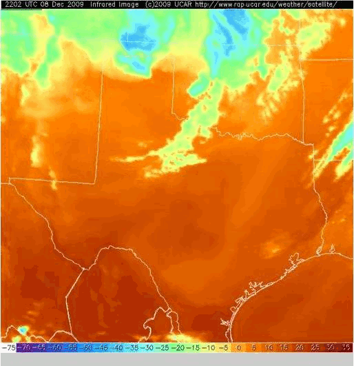
The progress of the front has been highlighted in a few key images below.


A higher spatial resolution loop (but at a lower temporal resolution) can be found at this link.
Pretty cool, eh?
Return to main page.