
|
|
|
|
|
|
|
|
|
|
|
|
|
|
|
|||||||
|
|
|
|
|
|
|
|
|
||
 Figure 1 -
Satellite orbit period vs. orbit radius.
Figure 1 -
Satellite orbit period vs. orbit radius.
 Figure 2 -
Satellite orbit period vs. orbit radius, continued.
Figure 2 -
Satellite orbit period vs. orbit radius, continued.
 Figure 3 -
GOES satellite.
Figure 3 -
GOES satellite.
 Figure 4 -
Height conditions for a geostationary satellite.
Figure 4 -
Height conditions for a geostationary satellite.
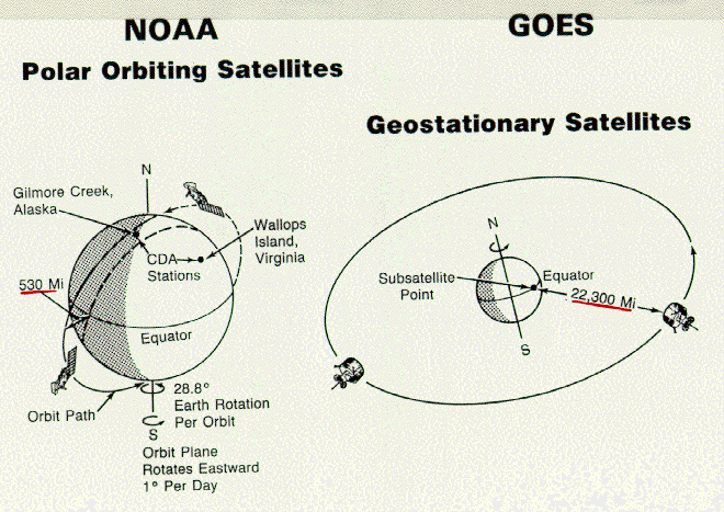 Figure 5 -
NOAA and GOES satellites.
Figure 5 -
NOAA and GOES satellites.
 Figure 6 -
GOES geographic coverage.
Figure 6 -
GOES geographic coverage.
 Figure 7 -
Data products.
Figure 7 -
Data products.
 Figure 8 -
Solar flare effects.
Figure 8 -
Solar flare effects.
 Figure 9 -
Advanced TIROS - N (ATN)
Figure 9 -
Advanced TIROS - N (ATN)
 Figure 10 -
One-polar soundings for 00Z map.
Figure 10 -
One-polar soundings for 00Z map.
 Figure 11 -
TIROS polar-orbiting environmental satellite.
Figure 11 -
TIROS polar-orbiting environmental satellite.
 Figure 12 -
Fundamental polar satellite products: AVHRR
Figure 12 -
Fundamental polar satellite products: AVHRR
 Figure 13 -
AVHRR channels.
Figure 13 -
AVHRR channels.
 Figure 14 -
Two-polar soundings for 00Z map.
Figure 14 -
Two-polar soundings for 00Z map.
 Figure 15 -
Fundamental polar satellite products: TIROS operational vertical sounder.
Figure 15 -
Fundamental polar satellite products: TIROS operational vertical sounder.
 Figure 16 -
Fundamental polar satellite products: TVOS.
Figure 16 -
Fundamental polar satellite products: TVOS.
 Figure 17 -
Atmospheric soundings.
Figure 17 -
Atmospheric soundings.
 Figure 18 -
Summary of fundamental polar-orbiting satellite products.
Figure 18 -
Summary of fundamental polar-orbiting satellite products.
 Figure 19 -
Derived polar satellite products.
Figure 19 -
Derived polar satellite products.
 Figure 20 -
Landsat orbit.
Figure 20 -
Landsat orbit.
 Figure 21 -
Multispectral Scanner (MSS) sensor.
Figure 21 -
Multispectral Scanner (MSS) sensor.
 Figure 22 -
Landsat image of Detroit.
Figure 22 -
Landsat image of Detroit.
 Figure 23 -
Thematic Mapper (TM) sensor.
Figure 23 -
Thematic Mapper (TM) sensor.
Related Class Images
 NESDIS programs.
 Operational earth observation satellites.
 Two types of satellites.
 Black body emission spectra for the sun and earth.
 Fundamental polar satellite products: HRPT
 Fundamental polar satellite products: APT
 Search and rescue system.
 Polar satellite communications link summary.
 Collection of polar satellite data.
 Polar satellite communications links to processing center.
 Processing data from polar satellites.
 Domestic users.
 Collection of geostationary satellite products.
 International weather satellites.
 Earth Observing System (EOS): Mission to Planet Earth.
 NSAT and TRMM.
 TOPEX/POSIEDON mission.
Satelllte Data Shows Global Sea Level Rise
 Upper atmosphere research satellite.
 An abridged guide to climatic remote sensing.
Back to Unit Page