
|
|
|
|
|
|
|
|
|
|
|
|
|
|
|
|||||||
|
|
|
|
|
|
|
|
|
||
Introduction
Satellites have played an increasingly more important role in making remote observations and measurements
of global environmental parameters. Begun with the launch of TIROS
1 on 1 April 1960, these satellite
measurements have provided increasingly more detailed information through an expanding network of ever
more sophisticated sensors. The attached photograph is the first complete view of the world's weather from
the TIROS IX satellite on 13 February 1965. In this unit we will get an overview of environmental satellites
deployed by the US and other countries. We will start by reviewing the physical concepts governing satellite
motions and constraints on where satellites are deployed to orbit. Satellite sensors and the physical properties
of the atmosphere, ocean, biosphere, and cryosphere (ice masses) will be overviewed. Much of the basic information
in this unit comes from NOAA (1985). Satellite motions are governed by the balance between the force of gravity
and the centrifugal force due to the satellite's orbital velocity. Figure 1 gives the factors in each of
these forces. Figure 2 gives the condition for a constant-radius
orbit and the derivation of the equation giving the orbital period.
Geostationary Operational Environmental Satellites (GOES)
Figure 3
For the special case of when the period of rotation exactly matches the rotational period of the earth (24 hours) and if the satellite is placed in orbit over the equator, then it will appear (when viewed from the earth) to be stationary over a particular point on the earth. This unique condition requires that the height of the satellite above the earth should be (Figure 4)
h = [(G*ME)/(T/2¶)2]1/3 - RE
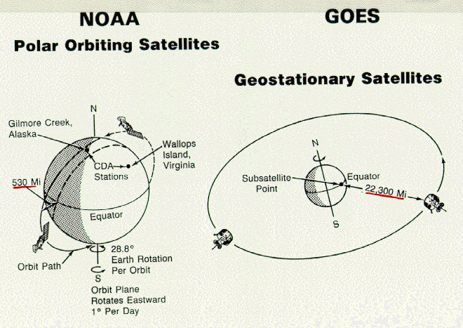
The position for such a satellite is about 36,000 km (22,300 miles) above a fixed point on the earth's surface known as the sub-satellite point (Figure 5). These satellites have the advantage that tracking devices are not required to receive their signals, so fixed dishes, similar to a typical TV dish, are suitable for transmitting and receiving signals from these satellites. Their large distance from the earth provide an advantageous perspective for geostationary satellites to view the entire face of the earth simultaneously, which is particularly useful for snapshots of large-scale cloud patterns. GOES satellites are placed in stationary earth orbits at locations designed to give maximum coverage for the particular application. For example, the US National Oceanic and Atmospheric Administration has 2 GOES satellites (Figure 6 ), one over the equator at 75 oW and the other at 135 oW. These two satellites give coverage of +/- 50o latitude and longitude from the sub-satellite point, which allows continuous coverage of the continental US and adjacent oceans. In periods when one satellite fails, the other can be moved to 1000 W, which gives suitable coverage over the continental US, but fails to give data from the northeast Pacific Ocean, from which region storms frequently enter the US. Data received from GOES satellites may be of several types (Figure 7). Image (picture) data in both visible (reflected solar light) and infrared (emitted from the earth, atmosphere, water vapor, and clouds) are recorded by the Visible and Infrared Spin Scan Radiometer (VISSR). The VISSR Atmospheric Sounder (VAS) measures the vertical structure of temperature and water vapor in the atmosphere for initializing weather forecast models. The GOES also has a Space Environment Monitor (SEM) for monitoring earth magnetic fields, solar storms, and sunspots (Figure 8). Some weather-related products derived from GOES data include:
The NOAA website provides updated information on the GOES satellites.
Polar-Orbiting Satellites
A disadvantage of geostationary satellites (Figure 9) is that their large
distance from the earth's surface compromises their ability to capture fine
detailed resolution of the planet surface. Satellites put in low earth orbit,
typically 850 km (531 miles) above the surface, can resolve topographic and
other environmental features as small as 1 km, and perhaps even much smaller.
However, this close proximity to the earth's surface limits their field of view
to a swath about 2,500 km (1,560 miles) wide as the satellite orbits the
planet. Maximum areal coverage is achieved if the satellite orbits from pole
to pole (Figure 10). By use of
the last equation of the height derivation, with a satellite height above
ground of 850 km, we get an orbital period of about 100 minutes. The satellite
orbiting from pole to pole crosses the equator going from south to north every
100 minutes, and between these equator crossings the planet will have rotated
by 28.8o. This allows the satellite to view a new swath that is
adjacent to the west of the swath from the previous pass. By manipulating the
height of the satellite, as can be seen from the equation for satellite period,
the orbital period can be adjusted to give the desired degree of overlap
between adjacent sweeps across the equator. Polar orbiting satellites are sufficiently
close to the earth's surface to acquire high resolution data
(Figure 11).
The NOAA website provides updated information on polar orbiting satellites.
Active and Passive Sensors
Some satellite sensors collect incoming randiant energy in various wavelengths.
These are called passive sensors. Others send out a radar or lidar (laser radar)
signal toward the Earth, which is then bounced back to and recorded by the
satellite. Such a sensor is called an active sensor. Most sensors are passive,
but a few important sensors are active.
Satellite Measurements
Polar orbiting satellites,
like GOES, have vertical sounding units for monitoring temperature and moisture. A second
type of instrument on polar orbiting satellites is the radiometer, which measures
energy at individual wavelengths of both visible and infrared radiation. The
Advanced Very High Resolution Radiometer (AVHRR) (Figure 12)
senses data in 5 different channels at both 1 km and 4 km resolution. Examples
of data from the AVHRR are given in
Figure 13. Polar orbiting satellites also provide image data for a variety
of environmental assessment needs and space environmental monitors similar to
those on the GOES satellites. Gathering weather data for use in initializing
weather forecasts requires at least daily and hopefully twice daily or more
frequent observations. By placing two companion satellites in synchronous low
polar orbits, we can acquire data over the entire surface of the earth on a
daily (or more frequent) basis (Figure 14).
A companion pair of polar orbiting satellites can be synchronized (called sun synchronous) so
that one passes over the particular location in the morning and the other passes overhead at
this location in the early evening. Note that the converging tracks of adjacent
orbits give multiple measurements in polar regions. Each satellite takes about
600 vertical profiles of measurements each day. Each profile of measurements
includes temperature at 15 levels, precipitable water at 3 levels, total column ozone, cloud cover,
and tropopause height (Figure 15). An example of
data derived from a sounder is given in Figure 16.
By making such measurements over each of the points in a 3-dimensional volume of
atmosphere (Figure 17), polar-orbiting satellites
provide data for use in computer models used for weather forecasts. A summary of fundamental
products of polar orbiting satellites are given in (
Figure 18) and derived satellite products in the following figure
(Figure 19).
A special NASA polar orbiting satellite, no longer in operation but from which data are still used, is the Landsat satellite (Figure 20) which had a multispectral scanning sensor (Figure 21). Its very low orbit of 706 km (438 miles) allowed it to get very high resolution images of the earth as is shown for Detroit (Figure 22). Another instrument, the thematic mapper (Figure 23) operated in both visible and infrared to give detailed land surface images.
International Deployment of Satellites
Several countries now have satellites in operation (Conway et al, 1997). Russia operates a series of
polar orbiting satellites known as Sich/OKEAN (with the Ukraine), the METEOR series, Resors, and MIR -Priroda. Russia also operates a geostationary satellite known as GOMS that transmits infrared images
and standard weather maps. China operates the Feng Yun polar orbiter that transmits imagery (pictures)
from both visible and infrared sensors.
Japan operates the geostationary meteorological satellite (GMS) with provides visible and infrared
images over the western Pacific Ocean, East Asia, and Australia. Japan also has a Marine Observation
Satellite (MOS) and, jointly with the US, measures rainfall remotely with the Tropical Rainfall Measuring
Mission (TRMM). The Indian government operates a geostationary satellite providing distribution of weather
maps. The METEOSAT series of geostationary satellites operated by the European Space Agency provides imagery
and weather map distribution over Europe and Africa. The European Space Agency also have
the ERS series and
Envisat.
Numerous other countries now also operate satellites for weather forecasting and
other purposes.
Science Missions for Studying Planet Earth
Current (2006) satellites used for global change studies include ACRIMSAT, Aqua, Aura, CHAMP, GOES-M, GRACE, IceSAT, Jason-1, Landsat 7, NMP EO-1, NOAA-M, SAGE-3, Sec Winds
(ADEOS-11), SORCE, Terra, TOMS-EP, and TRMM. Numerous
future missions
of NASA promise even better measurements of atmospheric, surface, and subsurface
variables of importance to global change.
NASA's Science Mission involves a variety of satellite and satellite sensors.
Satellites presently in operation for studying the Earth and influences on Earth
due to the sun and other sources outside Earth are listed under Earth-Sun
Missions.